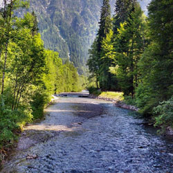
The Yellowstone River is the principal tributary of the upper Missouri River, and extents approximately 692 miles (1,114 km) in length. The drainage basin stretches from the Rocky Mountains in Yellowstone National Park across the mountains and through the high plains of southern Montana and northern Wyoming. It is the longest undammed river in the lower 48 states.
The river starts where the North Fork and the South Fork Yellowstone Rivers converge. The North Fork, the larger of the two forks, flows from Younts Peak. The South Fork flows from the southern slopes of Thorofare Mountain. The Yellowstone River flows northward through Yellowstone National Park, feeding and draining Yellowstone Lake, then dropping over the Upper and Lower Yellowstone Falls at the head of the Grand Canyon of the Yellowstone. After passing through the Black Canyon of the Yellowstone, the river then flows northward into Montana between the northern Absaroka Range and the Gallatin Range in Paradise Valley. The river emerges from the mountains near the town of Livingston, where it turns eastward and northeastward, flowing across the northern Great Plains past the city of Billings, Montana.
East of Billings, it is joined by the Bighorn River. Further downriver, it is joined by the Tongue River near Miles City, and then by the Powder River in eastern Montana. It flows into the Missouri River near Buford, North Dakota just upstream from Lake Sakakawea. At the confluence with the Missouri, the Yellowstone is actually the larger river.
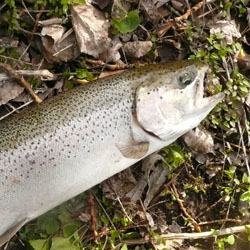
The Yellowstone River is considered to be one of the best trout streams in the world. It is classed as a blue ribbon trout stream in Montana, from the park to the confluence with the Boulder river east of Livingston and from the mouth of Rosebud creek near Rosebud, to the North Dakota border.
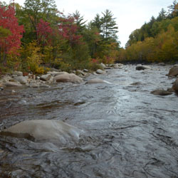
The lack of dams along the river makes it an excellent trout habitat. Most notably in the section from inside Yellowstone Park, downstream through Gardiner, the Paradise Valley, Livingston, and to Big Timber, a stretch of nearly 200 miles (320 km). The Yellowstone varies in width from 74 feet (23 m) to 300 feet (91 m), so fishing is normally done by boat. The most productive stretch of water is through Paradise Valley in Montana, especially near Livingston which produces brown trout, rainbow trout and native cutthroat trout as well as Rocky Mountain whitefish. From Billings downstream to the North Dakota border, anglers seek Burbot, Channel catfish, Paddlefish, Sauger, Smallmouth bass, and Walleye.
It is also important to note that a Yellowstone National Park Fishing Permit is required to fish in the park. Fishing permits are available at all ranger stations, visitor centers, and Yellowstone Park General Stores. Fishing permits are also available at many businesses in the Greater Yellowstone Area. No state fishing license is required when fishing inside Yellowstone National Park.
Yellowstone Lake to Yellowstone Falls
The river inside Yellowstone National Park provides many flat water fishing opportunities. The portion of the river through the Hayden Valley is closed all year long, but the rest is easily accessible and wadable. No floating is allowed. Numerous insect hatches occur providing anglers the opportunity to try numerous artificial flies including Pale Morning Duns, Green Drakes, Gray Drakes, Caddis and salmon flies. The target species in this section is the Yellowstone cutthroat trout.
Grand Canyon of the Yellowstone and Black Canyon of the Yellowstone
The canyon reaches inside Yellowstone National Park are accessible only by hiking or horseback. The river here is usually quite swift, with sheer canyon walls in spots. Below Knowles Falls, about four miles upstream from Gardiner, anglers will find browns and whitefish in addition to the rainbows and cutthroat trout.
Gardiner to Yankee Jim Canyon
This section of the Yellowstone holds a good population of medium-sized rainbow and cutthroat trout, with a few big browns as well. The first half of this section from Gardiner to the bridge at Corwin Springs is mostly fast water, with some class II and III white water. From Corwin Springs to Yankee Jim Canyon, the river flattens out substantially and provides the angler with more pools to fish along the banks.
Yankee Jim Canyon
Yankee Jim Canyon is the Yellowstone's best white water, with several major rapids. Steep canyon walls make it a difficult stretch to fish. Because of the potential dangers, many fishing guides do not float this stretch, although recreational floaters are common.
Tom Miner Bridge to Emigrant
From the Tom Miner Bridge (or the Carbella access just downstream) down to Point of Rocks, there is some excellent water, lots of fast pocket water with several nice pools. Once the river reaches the Point of Rocks, the gradient decreases substantially and the river flows slower, with larger pools.
Emigrant to Mallard's Rest
Just downstream from Emigrant is Grey Owl, one of the best fishing access points on the river. From here down to Mallard's Rest there is a pleasant mix of big pools and large browns and rainbows.
Mallard's Rest to Carter's Bridge
| This section of river known as Paradise Valley provides some of the most spectacular scenery on the Yellowstone, along with some of the best fishing. The scenery is dominated by the Absaroka Mountains to the east and the Gallatin Mountains to the west. Along this stretch numerous spring creeks flow into the river, many of which are blue ribbon trout streams in their own right, such as DePuy Spring Creek. Rainbows dominate this part of the river, but browns can be found here as well. |
 |
Carter's Bridge to Highway 89 Bridge
Because the Yellowstone flows right through Livingston between these points, this is known as the "town stretch". Given the presence of the upstream spring creeks for spawning, this stretch of fast water is ideal habitat for rainbows which make up most of the catch here. The use of a drift boat is the best way to access this stretch, though there are some good access points for walking and wading as well.
Highway 89 Bridge to Big Timber
This section starts about five miles to the east of Livingston, just off Interstate 90, where Highway 89 turns north, toward White Sulphur Springs. This lower river, down through Big Timber is similar to the water around Livingston, but the riffles and pools are farther apart so there is more unproductive water. The fish populations are not as high as in the upper river, but there are some very large rainbows and browns to be caught in this stretch. In late summer, wind gusting across hayfields blows a lot of grasshoppers into the river which creates a feeding frenzy for big trout. Using dry flies which imitate these terrestrial insects can produce explosive top water action.

Fishing Hot Spots Topo Maps
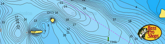
Each detailed map provides depth, contours, structure, boat ramps, and updated fishing information. Yellowstone River fishing maps also include lake info such as gamefish abundance, forage base, water clarity, weedline depth, bottom composition, complete latitude/longitude grid lines and dozens of GPS waypoints & coordinates.
» Fishing Maps |

))/950845.json?hei=600&wid=600&$Soc_facebook$)
|
Magic Bait Crappie Bites
Magic Baits Crappie Bites are a great way to turn a slow slab day into a full-basket, record-breaking day. Proven effective time and time again, Crappie Bites...
READ MORE
|
))/4657602.json)
|
Musky Mayhem Jr. Double Cowgirl
A greature for muskies and big pike, the Musky Mayhem Jr. Double Cowgirl is a smaller version of the Double Cowgirl...
READ MORE
|
))/1444408.json)
|
Sufix Performance 150 Yard Spool Braid
Sufix Performance Braid is built with the high strength and durability needed for the toughest offshore battles, while suppleness and small diameter...
READ MORE
|
Tag Cloud
access black bass boat launch gps coordinates cottage crappie fishin fishing information Yellowstone River map marina marked parks productive provide resorts search specific specified spots stories tips topo waters waypoints tackle shop bait lures live fishing lodge guide charter service dropshot trolling casting spinning fly
|